
The geography of Metro Vancouver creates a distinct real estate landscape where natural topography heavily dictates property valuation. In Burnaby, elevated hillsides, proximity to freshwater lakes, and unencumbered sightlines toward the North Shore Mountains establish significant pricing differentials between homes with panoramic views and those with obstructed outlooks. Assessing the monetary value of a view requires evaluating multiple visual factors, including directional orientation, horizon depth, spatial permanence, and ambient light exposure. For buyers, sellers, and appraisers, understanding how view premiums are calculated across different Burnaby micro-markets is essential for making informed investment decisions. This article examines the architectural and market variables that turn a scenic backdrop into quantifiable home equity.
The Architectural Science of View Classification
Not all elevated perspectives carry equal financial weight in real estate appraisal. Valuers classify views based on scope, subject matter, and unobstructed visual angles. A home situated near Burnaby Mountain offering a sweeping, unobstructed vista of Burrard Inlet commands a fundamentally different market premium than a property with a narrow, diagonal corridor view between neighboring structures.
In residential valuation, views are broadly grouped into three visual tiers:
| View Classification | Visual Parameters & Sightlines | Dominant Geographical Features |
| Panoramic Unobstructed | 180 to 360-degree clear horizon with zero structural interference | North Shore Mountains, Burrard Inlet, Downtown Vancouver Skyline |
| Partial / Corridor | Narrow visual windows frameable between buildings or foliage | Framing of Metrotown skyline, Deer Lake, or distant mountain peaks |
| Ground-Level Landscape | Localized green space, parkland, or neighborhood greenery | Greenbelts, Golf Courses, Pacific Spirit / Central Park tree canopies |
The nature of the sightline determines buyer appeal. Mountain and water vistas consistently command higher premiums due to their dramatic topography and perceived permanence. Conversely, urban skyline views, such as those overlooking the high-rise corridors of Metrotown or Brentwood, appeal strongly to buyers seeking modern cityscapes, though their long-term visibility can be affected by ongoing high-density infill development.
Topography and Neighborhood Micro-Markets in Burnaby
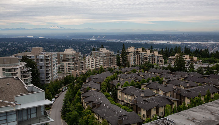
Burnaby’s varied terrain creates distinct valuation pockets where view premiums fluctuate based on elevation and zoning restrictions. The city’s geographic structure allows certain neighborhoods to capture superior sightlines compared to flat basin areas.
Capitol Hill and Burnaby Heights
Capitol Hill stands as one of the premier view locations in the municipality. Situated on a steep northern slope, properties in this enclave frequently offer uninterrupted panoramic sightlines stretching across Burrard Inlet, Indian Arm, and the North Shore Mountains. Because of the sharp topographical drop, homes on the high side of northern avenues retain permanent visual dominance, resulting in substantial property value surcharges compared to similar interior lots.
Burnaby Mountain and Universities
The slopes surrounding Simon Fraser University benefit from high elevation. Properties situated along the ridge capture expansive eastern and northern views. However, architectural design must account for seasonal weather patterns, as higher elevations in Burnaby frequently experience localized cloud cover or fog during winter months, temporarily altering visual appeal.
Deer Lake and Buckingham Heights

In central Burnaby, sightlines transition from dramatic ocean vistas to peaceful natural settings. Buckingham Heights and the perimeter streets around Deer Lake offer elevated perspectives overlooking parkland, quiet waters, and southern valley horizons. In these neighborhoods, views are prized for privacy and natural greenery rather than high-density urban skylines.
| Burnaby Neighborhood | Primary View Type | Dominant Topography | Valuation Impact Factor |
| Capitol Hill | Water, Mountain, and Marine Port | Steep Northern Slope | Premium valuation due to permanent elevation drops |
| Buckingham Heights | Lake, Park, and Southern Valley | Gradual Ridge | High valuation driven by greenbelt proximity and privacy |
| Brentwood / Lougheed | Urban Skyline and Distant Peaks | High-Rise Elevation | Tiered valuation based on floor height in strata towers |
| Suncrest / South Burnaby | Fraser River and Southern Horizon | Terraced Southern Slope | Moderate to high premium for sunny southern exposure |
Quantifying the View Premium on Property Appraisals
Appraising a property with a view requires separating the intrinsic value of the land and building footprint from the intangible value of the surrounding vista. Appraisers utilize comparative market analysis (CMA) by isolating transactions of structurally similar homes within the same immediate subdivision to establish baseline values.
When a property with a premium view is compared against an identical home lacking a sightline, the price differential reveals the specific monetary premium attached to the view. In Metro Vancouver markets, unobstructed mountain and water views can add anywhere from 10 percent to over 30 percent to a property’s total market value, depending on the exclusivity of the view corridor.
Understanding how landscape elements, floor height, and lot orientation shape property pricing is critical when evaluating real estate assets. Homeowners seeking clarity on how their specific location and vista influence market position often askwhat is my Burnaby home worth when preparing a property for competitive listing.
Vertical Elevation in Strata Developments
The influence of sightlines extends beyond single-family detached homes into multi-family high-rise developments. In high-density urban centers like Metrotown, Lougheed, and Brentwood, developers utilize floor-level pricing multipliers to reflect visual superiority.
In concrete residential towers, identical floor plans incur price increases with each ascending level. Lower floors often overlook street traffic or adjacent structures, whereas upper floors clear surrounding rooftops to reveal mountain ranges or regional skylines.
| Tower Vertical Zone | Typical View Characteristics | Pricing Structure Dynamics |
| Low-Rise (Floors 1-5) | Streetscape, courtyard, or tree-canopy level | Baseline unit pricing; higher exposure to ambient noise |
| Mid-Rise (Floors 6-15) | Partial urban view; framed by neighboring towers | Standard vertical price increments per floor level |
| High-Rise (Floors 16-30) | Above tree line; clear urban and mountain horizon | Accelerating floor premiums due to expansive sightlines |
| Penthouse / Sub-Penthouse | Unobstructed 180 to 360-degree regional vistas | Exceptional premium pricing detached from standard floor increments |
Beyond sheer height, unit orientation within a tower plays a decisive role. North-facing units that showcase the North Shore Mountains and west-facing units that capture evening sunsets consistently command higher resale prices than south-facing or east-facing units on equivalent floors.
Protecting Sightline Value: Zoning and Vegetation Control
A primary concern for owners of view properties is protecting sightline permanence over time. A view that exists today can be degraded tomorrow by real estate development or unmanaged vegetation.
Municipal Zoning Restrictions
In detached housing single-family zones, municipal building bylaws govern maximum building heights, roof pitches, and setbacks. These regulations help prevent new construction from inappropriately blocking neighboring perspectives. However, in areas designated for urban densification under municipal official community plans, older low-rise views may eventually be altered by high-density transit-oriented developments.
Tree Growth and Landscape Maintenance
Unlike structural additions, tree growth occurs gradually and can incrementally obscure sightlines over years. In British Columbia, property owners do not hold an automatic common-law right to a view across neighboring private land. Unless a formal view covenant is registered on a neighboring property’s land title, property owners cannot legally force neighbors to trim trees or vegetation that grow to block their horizon. Buyers assessing view homes must verify whether surrounding trees sit on private property, municipal land, or protected parkland.
Conclusion
A property’s sightline is a powerful driver of residential real estate value in Burnaby. Whether it is an expansive mountain landscape in Capitol Hill, a tranquil water view near Deer Lake, or a sweeping urban skyline from a Brentwood high-rise, scenic perspectives enhance living quality and provide strong equity protection. By analyzing elevation, directional exposure, zoning stability, and sightline permanence, buyers and sellers can accurately evaluate the financial value of a view and make strategic decisions in Burnaby’s dynamic housing market.
